
Mizoram
Mizoram Population 2019/2020
Mizoram Population in Crores is 0.12 Crores
(February 2019 estimates till December 2018 as per Aadhar Uidai)
List of Districts, Cities & Towns in Mizoram
mizoram map
About Mizoram
Aizwal is the Capital of Mizoram in india. One of the youngest States of the Union, Mizoram is flanked by Tripura & Bangladesh on the west, Myanmar on the east & south and Manipur as well as Assam on the north. Its exact geographical location is 92o15 to 93o29 East Longitude and 21o58 to 24o35 North Latitude. The Tropic of Cancer runs just on the southern periphery of the State Capital Aizawl. Although Mizoram is a tiny state having an area of only 21081 sq. km., it has as much as 404 km. of international border with Myanmar and 318 km. with Bangladesh. Having one of the most enchanting hilly terrains in eastern India, the hills of Mizoram are steep and divided by deep gorges and numerous streams and rivers flow either from north to south or from south to northernly direction. Generally not so warm in summer and not very cold during rainfree winter, the climate is very comfortable. Although majority of the population are cultivators, Mizos are extremely fond of all good things in life and have one of
Aizawl the capital of Mizoram is 180 kms. from Silchar, Assam which is the the most closely knit society in the whole of the country. Most of the Mizo are Christian. In the field of literacy, the only competitor is the State of Kerala and Mizos are proud to take part in this healthy competition. nearest railhead. The bus journey from Silcahr to Aizawl usually takes about 6 hrs. Mizoram State Transport Buses ply between Aizawl and Silchar daily. Mizoram is also connected by daily flight from Kolkata and Guwahti.
Mizoram is one of the North-Eastern states of India the state comprising of 8 districts, 23 towns and 719 inhabited villages. The provisional population of Mizoram as on 1st March, 2011 has recorded as 1091014 consisting of 552339 males and 538675 female. With this population Mizoram contributes 0.09 percent to the total population of the country and in terms of population its rank is 29th among all states and union territories of the nation.
The District wise distribution of villages and towns is as follows:-
| Districts | No.of inhabited villages | No.of Towns |
| Mamit | 87 | 3 |
| Kolasib | 39 | 4 |
| Aizawl | 97 | 4 |
| Champhai | 84 | 4 |
| Serchhip | 34 | 3 |
| Lunglei | 163 | 3 |
| Lawngtlai | 161 | 1 |
| Saiha | 54 | 1 |
| 719 | 23 |
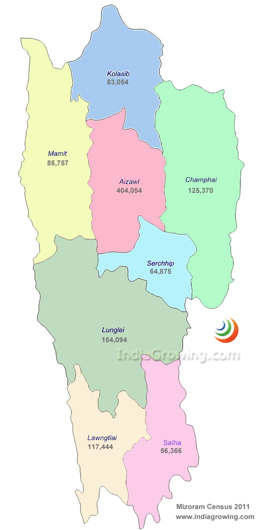
Distribution of Population, Decadal Growth Rate, Sex-Ratio and Population Density
| Population 2011 | Decadal growth | Sex Ratio | ||||||
| District Code | State/District | Persons | Male | Females | 1991-01 | 2001-11 | 2001 | 2011 |
| Mizoram | 1,091,014 | 552,339 | 538,675 | 28.82 | 22.78 | 935 | 975 | |
| 01 | Mamit | 85,757 | 44,567 | 41,190 | -2.77 | 36.59 | 896 | 924 |
| 02 | Kolasib | 83,054 | 42,456 | 40,598 | 35.25 | 25.92 | 908 | 956 |
| 03 | Aizawl | 404,054 | 201,072 | 202,982 | 38.07 | 24.07 | 952 | 1009 |
| 04 | Champhai | 125,370 | 63,299 | 62,071 | 29.84 | 16.31 | 944 | 981 |
| 05 | Serchhip | 64,875 | 32,824 | 32,051 | 17.82 | 19.12 | 967 | 976 |
| 06 | Lunglei | 154,094 | 79,252 | 74,842 | 23.16 | 12.29 | 922 | 944 |
| 07 | Lawngtlai | 117,444 | 60,379 | 57,065 | 34.87 | 34.08 | 909 | 945 |
| 08 | Saiha | 56,366 | 28,490 | 27,876 | 34.80 | 19.71 | 950 | 978 |
