
Rajasthan
Rajasthan is the largest state of India with an area of 342,238 sq km, bordered by Pakistan in the west, Gujarat in the south, New Delhi in the east. Rajasthan occupies 10.4% of Indian demographic area and seventh largest state by population. Thar desert is the largest desert in Rajastan which covers around 175,000 sq km of the state also known as Great Indian Desert which is extended to Gujarat, Punjab and Haryana. Rajasthan state is divided into 33 districts with Jaipur as state capital. The main spoken languages are Rajasthani and Hindi. Bordering districts of country Pakistan are Jaisalmer, Bikaner and Sri Ganganagar.
Rajasthan Population 2024
Population in Crores is 7.82 Crores
(February 2019 estimates till December 2018 as per Aadhar Uidai)
| Capital | Jaipur |
| Languages | Rajasthani, Hindi |
| Population | 68621012 (2011 Census) |
| Density | 200 per sq km |
| Total Area | 3,42,239 sq km |
| Gov website | http://www.rajasthan.gov.in |
| District Code | State/ District | Population - 2011 | Percentage Decadal Growth Rate of Population | Sex Ratio (No. of Females per 1000 Males) | Population density per Sq. Km | ||
|---|---|---|---|---|---|---|---|
| Person | Male | Female | 2001-11 | 2011 | 2011 | ||
| 1 | 2 | 3 | 4 | 5 | 7 | 9 | 11 |
| 08 | Rajasthan | 68621012 | 35620086 | 33000926 | 21.44 | 926 | 201 |
| 01 | Ganganagar | 1969520 | 1043730 | 925790 | 10.06 | 887 | 179 |
| 02 | Hanumangarh | 1779650 | 933660 | 845990 | 17.24 | 906 | 184 |
| 03 | Bikaner | 2367745 | 1243916 | 1123829 | 24.48 | 903 | 78 |
| 04 | Churu | 2041172 | 1053375 | 987797 | 20.35 | 938 | 148 |
| 05 | Jhunjhunun | 2139658 | 1097390 | 1042268 | 11.81 | 950 | 361 |
| 06 | Alwar | 3671999 | 1938929 | 1733070 | 22.75 | 894 | 438 |
| 07 | Bharatpur | 2549121 | 1357896 | 1191225 | 21.39 | 877 | 503 |
| 08 | Dhaulpur | 1207293 | 654344 | 552949 | 22.78 | 845 | 398 |
| 09 | Karauli | 1458459 | 784943 | 673516 | 20.94 | 858 | 264 |
| 10 | Sawai Madhopur | 1338114 | 706558 | 631556 | 19.79 | 894 | 297 |
| 11 | Dausa | 1637226 | 859821 | 777405 | 23.75 | 904 | 476 |
| 12 | Jaipur | 6663971 | 3490787 | 3173184 | 26.91 | 909 | 598 |
| 13 | Sikar | 2677737 | 1377120 | 1300617 | 17.04 | 944 | 346 |
| 14 | Nagaur | 3309234 | 1698760 | 1610474 | 19.25 | 948 | 187 |
| 15 | Jodhpur | 3685681 | 1924326 | 1761355 | 27.69 | 915 | 161 |
| 16 | Jaisalmer | 672008 | 363346 | 308662 | 32.22 | 849 | 17 |
| 17 | Barmer | 2604453 | 1370494 | 1233959 | 32.55 | 900 | 92 |
| 18 | Jalor | 1830151 | 937918 | 892233 | 26.31 | 951 | 172 |
| 19 | Sirohi | 1037185 | 535115 | 502070 | 21.86 | 938 | 202 |
| 20 | Pali | 2038533 | 1025895 | 1012638 | 11.99 | 987 | 165 |
| 21 | Ajmer | 2584913 | 1325911 | 1259002 | 18.66 | 950 | 305 |
| 22 | Tonk | 1421711 | 729390 | 692321 | 17.33 | 949 | 198 |
| 23 | Bundi | 1113725 | 579385 | 534340 | 15.7 | 922 | 193 |
| 24 | Bhilwara | 2410459 | 1224483 | 1185976 | 19.27 | 969 | 230 |
| 25 | Rajsamand | 1158283 | 582670 | 575613 | 17.89 | 988 | 302 |
| 26 | Dungarpur | 1388906 | 698069 | 690837 | 25.39 | 990 | 368 |
| 27 | Banswara | 1798194 | 908755 | 889439 | 26.58 | 979 | 399 |
| 28 | Chittaurgarh | 1544392 | 784054 | 760338 | 16.09 | 970 | 193 |
| 29 | Kota | 1950491 | 1023153 | 927338 | 24.34 | 906 | 374 |
| 30 | Baran | 1223921 | 635495 | 588426 | 19.82 | 926 | 175 |
| 31 | Jhalawar | 1411327 | 725667 | 685660 | 19.57 | 945 | 227 |
| 32 | Udaipur | 3067549 | 1566781 | 1500768 | 23.63 | 958 | 242 |
| 33 | Pratapgarh* | 868231 | 437950 | 430281 | 22.84 | 982 | 211 |
Rajasthan Map, Population as per district
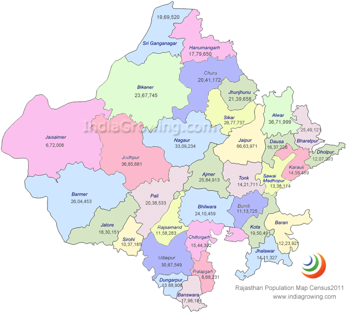
Rajasthan is India's largest state by area with 342,239 sq km and is divided into 33 districts. Jaisalmer is the largest district with an area 38,401 sq km. Population wise Jaipur is the capital and district with around 6,663,971 people living in this district as per 2011 census.
- India
- Andhra Pradesh
- Arunachal Pradesh
- Assam
- Bihar
- Chhattisgarh
- Delhi
- Goa
- Gujarat
- Haryana
- Himachal Pradesh
- Jammu & Kashmir
- Jharkhand
- Karnataka
- Kerala
- Madhya Pradesh
- Maharashtra
- Manipur
- Meghalaya
- Mizoram
- Nagaland
- Odisha
- Punjab
- Rajasthan
- Sikkim
- Telangana
- Tripura
- Tamil Nadu
- Uttarakhand
- Uttar Pradesh
- West Bengal
- Andaman and Nicobar Islands UT
- Chandigarh UT
- Dadra & Nagar Haveli UT
- Daman & Diu UT
- Lakshadweep UT
- Puducherry UT