
Wokha is a district in Nagaland State of India. It has a total of 12 Subdivisions in this district. Wokha population is estimated to be 234,544 in 2024.
Wokha is one of districts of Nagaland in India, Wokha population in 2024 is 234,544 (estimates as per aadhar data). As per 2011 census of India, Wokha has a population of 166,343 in 2011 out of which 84,505 are male and 81,838 are female. Population of Wokha in 2023 is estimated to be 231,217 and in 2022 is estimated to be 219,573 inhabitants. Literate people are 128,208 out of 67,385 are male and 60,823 are female. People living in Wokha depend on multiple skills, total workers are 78,412 out of which men are 42,096 and women are 36,316. Total 41,862 Cultivators are depended on agriculture farming out of 20,233 are cultivated by men and 21,629 are women. 2,375 people works in agricultural land as labor, men are 1,298 and 1,077 are women. Wokha sex ratio is 968 females per 1000 of males. Next Wokha Census will be in 2024-2025.Wokha is a district in Nagaland state in india.
Subdivision is the local administrative division mostly a town or city, Below is the Wokha District Subdivisions list in the state of Nagaland, Subdivision can be considered as sub-districts, As on the last 2011 census, Wokha is divided into 12 Subdivisions.
According to 2011 Census of India, Wokha District Subdivisions population, Below is the list of Wokha Subdivisions househods, total population and as per male and female statistics.
| Subdivisions | Population 2011 | Male | Female | Households |
|---|---|---|---|---|
| Changpang | 5,397 | 2,767 | 2,630 | 1,247 |
| Aitepyong | 16,194 | 8,357 | 7,837 | 2,800 |
| Bhandari | 17,124 | 8,949 | 8,175 | 3,739 |
| Baghty | 2,697 | 1,398 | 1,299 | 552 |
| Sungro | 13,046 | 6,488 | 6,558 | 2,292 |
| Sanis | 7,155 | 3,533 | 3,622 | 1,300 |
| Lotsu | 6,338 | 3,197 | 3,141 | 1,203 |
| Ralan | 8,627 | 4,416 | 4,211 | 2,061 |
| Wozhuro | 8,680 | 4,390 | 4,290 | 1,734 |
| Wokha Sadar | 58,186 | 29,467 | 28,719 | 10,878 |
| Englan | 12,856 | 6,484 | 6,372 | 2,220 |
| Chukitong | 10,043 | 5,059 | 4,984 | 1,865 |
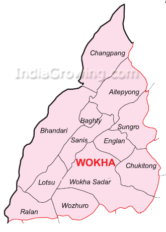 Wokha District Subdivisions Map