
Zunheboto is a district in Nagaland State of India. It has a total of 13 Subdivisions in this district. Zunheboto population is estimated to be 198,468 in 2024.
Zunheboto is one of districts of Nagaland in India, Zunheboto population in 2024 is 198,468 (estimates as per aadhar data). As per 2011 census of India, Zunheboto has a population of 140,757 in 2011 out of which 71,217 are male and 69,540 are female. Population of Zunheboto in 2023 is estimated to be 195,653 and in 2022 is estimated to be 185,800 inhabitants. Literate people are 102,881 out of 53,504 are male and 49,377 are female. People living in Zunheboto depend on multiple skills, total workers are 79,466 out of which men are 41,178 and women are 38,288. Total 30,738 Cultivators are depended on agriculture farming out of 14,787 are cultivated by men and 15,951 are women. 1,763 people works in agricultural land as labor, men are 858 and 905 are women. Zunheboto sex ratio is 976 females per 1000 of males. Next Zunheboto Census will be in 2024-2025.Zunheboto is a district in Nagaland state in india.
Subdivision is the local administrative division mostly a town or city, Below is the Zunheboto District Subdivisions list in the state of Nagaland, Subdivision can be considered as sub-districts, As on the last 2011 census, Zunheboto is divided into 13 Subdivisions.
According to 2011 Census of India, Zunheboto District Subdivisions population, Below is the list of Zunheboto Subdivisions househods, total population and as per male and female statistics.
| Subdivisions | Population 2011 | Male | Female | Households |
|---|---|---|---|---|
| V.K | 3,931 | 2,006 | 1,925 | 852 |
| Akuluto | 6,612 | 3,408 | 3,204 | 1,423 |
| Suruhuto | 13,957 | 7,209 | 6,748 | 2,782 |
| Asuto | 7,598 | 3,876 | 3,722 | 1,546 |
| Aghunato | 18,350 | 9,072 | 9,278 | 3,496 |
| Zunheboto Sadar | 35,977 | 18,345 | 17,632 | 6,703 |
| Atoizu | 8,740 | 4,320 | 4,420 | 1,731 |
| Akuhaito | 3,876 | 1,988 | 1,888 | 734 |
| Pughoboto | 8,943 | 4,454 | 4,489 | 1,931 |
| Ghathashi | 7,967 | 3,984 | 3,983 | 1,658 |
| Satakha | 15,103 | 7,796 | 7,307 | 2,984 |
| Saptiqa | 5,163 | 2,496 | 2,667 | 1,034 |
| Satoi | 4,540 | 2,263 | 2,277 | 961 |
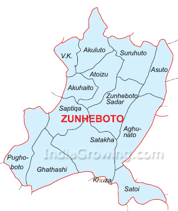 Zunheboto District Subdivisions Map